Technical Notes: Health regions
Individuals who receive an HIV diagnostic test are assigned to a geographic region based on their residence or, if not reported, the address of the ordering provider. Approximately 28% of diagnoses are missing information on address of residence in 2019 and assigned based on provider address.
Ontario can be divided geographically by health region or public health units (PHU). These are defined below:
- Health regions – Groupings of PHUs that have historically been used in HIV epidemiology and surveillance reports. See the following page for health region breakdowns.
- Public health unit – A health agency that provides health promotion and disease prevention programs. There are currently (2021) 34 PHUs in Ontario and each has its own unique geographical boundary. This is different from previous years where there were 36 PHUs (2017 and before). The change reflects the Oxford PHU being combined with the Elgin-St. Thomas PHU to form the new ‘Southwestern’ PHU. It also reflects Huron and Perth being combined. The larger health regions did not change from previous reports.
Groupings of public health units for each health region:
Toronto health region
- Toronto
Ottawa health region
- Ottawa
Northern health region
- Algoma
- North Bay Parry Sound
- Northwestern
- Porcupine
- Sudbury
- Thunder Bay
- Timiskaming
Eastern health region
- Eastern Ontario
- Hastings and Prince Edward Counties
- Kingston, Frontenac, Lennox & Addington
- Leeds, Grenville and Lanark
- Renfrew
Central East health region
- Durham
- Haliburton, Kawartha, Pine Ridge
- Peel
- Peterborough
- Simcoe Muskoka
- York
Central West health region
- Brant
- Haldimand-Norfolk
- Halton
- Hamilton
- Niagara
- Waterloo
- Wellington-Dufferin-Guelph
South West health region
- Grey Bruce
- Huron / Perth
- Chatham-Kent
- Lambton
- Middlesex-London
- Southwestern (Oxford, Elgin and St. Thomas)
- Windsor-Essex
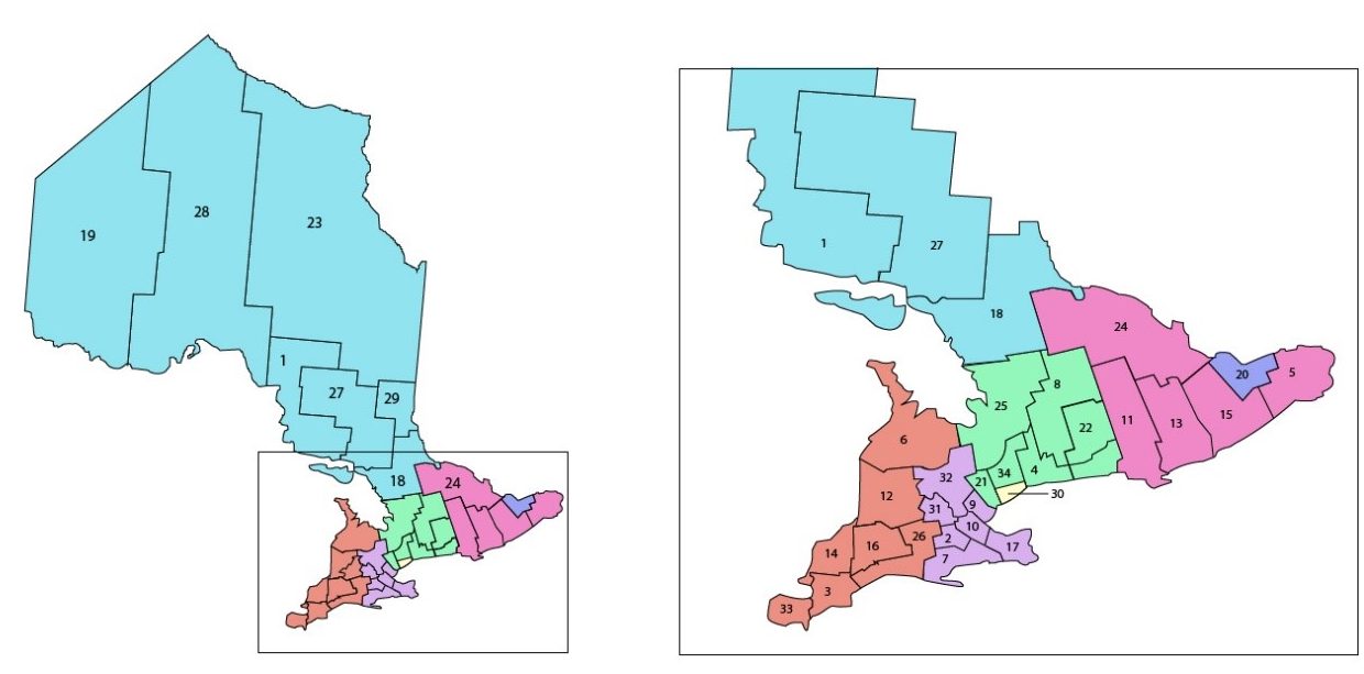
Figure i: Geographic map of health region and public health unit boundaries. Map created using Statistics Canada boundary files
Public health units (map legend)
1. Algoma
2. Brant
3. Chatham-Kent
4. Durham
5. Eastern Ontario
6. Grey Bruce
7. Haldimand-Norfolk
8. Haliburton, Kawartha, Pine Ridge
9. Halton
10. Hamilton
11. Hastings and Prince Edward Counties
12. Huron / Perth
13. Kingston, Frontenac, Lennox & Addington
14. Lambton
15. Leeds, Grenville and Lanark
16. Middlesex-London
17. Niagara
18. North Bay Parry Sound
19. Northwestern
20. Ottawa
21. Peel
22. Peterborough
23. Porcupine
24. Renfrew
25. Simcoe Muskoka
26. Southwestern
27. Sudbury
28. Thunder Bay
29. Timiskaming
30. Toronto
31. Waterloo
32. Wellington-Dufferin-Guelph
33. Windsor-Essex
34. York